
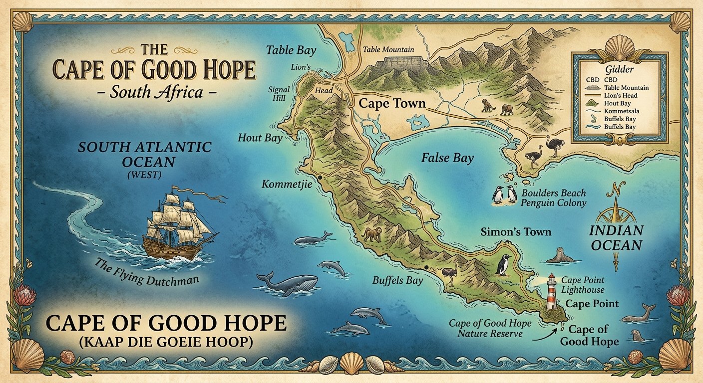

Introduction to the Cape of Good Hope Map
A cape of good hope map is a helpful resource for understanding one of the most famous coastal landmarks in South Africa. Located on the southwestern coast of the country, the Cape of Good Hope is known for its dramatic cliffs, beautiful ocean views, rich wildlife, and important place in maritime history. It attracts travelers, nature lovers, photographers, students, and geography enthusiasts from around the world.
When looking at a map of the Cape of Good Hope, you’ll find it near the southern end of the Cape Peninsula, southwest of Cape Town. The area forms part of Table Mountain National Park and is protected for its natural beauty and wildlife. Although many people believe the Cape of Good Hope marks the southernmost point of Africa, that distinction belongs to Cape Agulhas, which lies farther southeast.
A detailed map can help visitors understand the location of the cape, nearby beaches, walking trails, scenic viewpoints, and roads connecting it with Cape Town. It also explains why this remarkable destination has played such an important role in exploration and sea travel.
Whether you’re planning a trip, completing a school project, or simply exploring the world through maps, learning about the Cape of Good Hope offers an exciting look at geography, history, and nature.
Where Is the Cape of Good Hope Located?
The Cape of Good Hope is situated in the Western Cape province of South Africa. It lies on the Cape Peninsula, a long stretch of land extending southward from the Cape Town area into the Atlantic Ocean.
On a regional map, the cape appears near the southwestern edge of Africa. Cape Town is located to the north, while the coastal communities of the peninsula connect the city with the protected natural areas farther south.
The cape forms part of the Cape of Good Hope section of Table Mountain National Park. This protected area contains rocky coastlines, open grasslands, rugged hills, and several important wildlife habitats.
Geographic location at a glance
- Country: South Africa
- Province: Western Cape
- Region: Cape Peninsula
- Nearest major city: Cape Town
- Protected area: Table Mountain National Park
- General position: Southwestern coast of South Africa
- Nearby natural landmarks: Cape Point, False Bay, and the Atlantic coastline
The exact point shown on a map can vary depending on whether it marks the broader Cape of Good Hope area, the official geographic feature, or a nearby visitor viewpoint. Therefore, travelers should check the map legend and destination pin before starting their journey.
Understanding the Cape of Good Hope Map
A good map does more than show where a destination is located. It helps readers understand the landscape, identify nearby attractions, and plan a safe route.
When studying a cape of good hope map, look for the following features.
Roads and access routes
Roads connect Cape Town with the southern Cape Peninsula. Visitors commonly travel through areas such as Muizenberg, Simon’s Town, and the coastal roads leading toward the park.
Maps may show the main access roads, parking areas, park entrances, and smaller routes leading to specific viewpoints. However, road conditions, access restrictions, and opening arrangements can change, so current information should be checked before traveling.
Coastal features
The map may display the Atlantic Ocean to the west and the waters of False Bay to the east of the peninsula. The Cape of Good Hope area contains steep coastal cliffs, rocky shores, and exposed headlands.
These features help explain why the region has attracted sailors and explorers for centuries. The surrounding coastline can be beautiful, but strong winds, powerful waves, and sudden weather changes require care.
Trails and viewpoints
Walking routes and marked viewpoints are useful features on visitor maps. Some routes offer views of the ocean, while others cross open vegetation and rocky terrain.
A map can help visitors select a route that matches their available time and fitness level. Even a short walk can provide impressive views of the peninsula’s natural landscape.
Park boundaries
The Cape of Good Hope is part of a protected natural environment. Maps may identify conservation areas, visitor facilities, walking routes, and places where access is restricted.
Following these boundaries helps protect plants, wildlife, and sensitive coastal habitats.
Cape of Good Hope Map and Nearby Landmarks
The cape is not an isolated point on the map. It belongs to a larger region filled with scenic locations and historical attractions.
Cape Point
Cape Point is one of the best-known landmarks near the Cape of Good Hope. It features high cliffs, ocean views, and a famous historic lighthouse area.
Although the two names are often used as if they describe the same place, Cape Point and the Cape of Good Hope are distinct geographic features. They are close to each other within the same protected park area.
Visitors often explore both during a single trip because they offer different views of the peninsula.
Cape Town
Cape Town is the main urban center for most trips to the cape. It is known for Table Mountain, its waterfront, beaches, museums, and diverse cultural attractions.
The drive from Cape Town to the Cape of Good Hope generally takes around 1.5 to 2 hours in one direction, depending on the starting point, traffic, road conditions, and chosen route. Extra time should be allowed for stops along the way.
Simon’s Town
Simon’s Town is a coastal town on the eastern side of the Cape Peninsula. It is known for its naval history, seaside atmosphere, and access to Boulders Beach, where visitors can observe African penguins from designated viewing areas.
The town is a useful stop for travelers exploring the peninsula before or after visiting the cape.
Boulders Beach
Boulders Beach is famous for its African penguin colony. Boardwalks and designated viewing areas allow visitors to observe the birds while reducing disturbance to their habitat.
It lies north of the Cape of Good Hope and can be included in a day trip from Cape Town.
False Bay
False Bay lies on the eastern side of the Cape Peninsula. Its coastline includes beaches, fishing communities, and coastal settlements.
On a regional map, False Bay helps explain the peninsula’s shape and the difference between its eastern and western shores.
The Difference Between the Cape of Good Hope and Cape Agulhas
One of the most common geographic misunderstandings concerns the southernmost point of Africa.
The Cape of Good Hope is a famous landmark near the southwestern end of the Cape Peninsula. However, the southernmost point of the African continent is Cape Agulhas, farther southeast along South Africa’s coast.
This difference matters when reading maps because famous historical locations do not always match the continent’s geographic extremes.
| Feature | Cape of Good Hope | Cape Agulhas |
|---|---|---|
| Country | South Africa | South Africa |
| Province | Western Cape | Western Cape |
| Geographic role | Famous coastal headland | Southernmost point of Africa |
| Main significance | Maritime history, scenery, and conservation | Geographic meeting area of the Atlantic and Indian oceans |
| Nearby setting | Cape Peninsula and Cape Point | Southern coastal region near Agulhas |
| Visitor experience | Cliffs, wildlife, and scenic trails | Coastal scenery, lighthouse, and geographic landmarks |
Cape Agulhas is generally recognized as the meeting point of the Atlantic and Indian oceans for geographic purposes. The exact patterns of ocean circulation are more complex than a single line on a map, but the distinction remains important.
When using a cape of good hope map, remember that the Cape of Good Hope is famous for its history and scenery, while Cape Agulhas holds the title of Africa’s southernmost point.
The Historical Importance of the Cape of Good Hope
The Cape of Good Hope has a long history connected with maritime exploration and international trade. For centuries, sailors sought sea routes connecting Europe and Asia, and the waters around southern Africa became an important part of these journeys.
Early European voyages
Portuguese explorer Bartolomeu Dias reached the southern African region in 1488. His voyage demonstrated that European ships could navigate around the southern end of Africa and opened new possibilities for sea travel toward the Indian Ocean.
The cape was later named the Cape of Good Hope by the Portuguese king, traditionally associated with the hope of establishing a sea route to India.
A route to international trade
Before the Suez Canal opened in 1869, sailing around southern Africa was especially important for ships traveling between Europe and Asia. The route remained significant afterward, particularly when conditions or shipping needs made it useful.
The cape’s location made it an important reference point for navigation. Its rough waters and changing weather also gave it a reputation among sailors.
Maps and exploration
Historical maps show how knowledge of the African coastline improved over time. Early charts were less precise than modern maps, but they helped sailors understand coastlines, identify hazards, and plan voyages.
Today, digital mapping systems use satellite imagery, geographic information systems, and updated road information to provide much more detailed views of the area.
The Cape of Good Hope therefore connects the history of exploration with the modern science of mapping.
Physical Geography and Natural Landscape
The Cape of Good Hope lies within a region of remarkable physical diversity. Its landscape includes rocky headlands, steep cliffs, low hills, sandy beaches, and open coastal vegetation.
Rocky cliffs and headlands
The cliffs around the cape rise above the ocean and provide broad views of the surrounding coastline. Wind and waves continually shape the exposed rock, creating an environment that looks very different from the sandy beaches found elsewhere in the region.
Visitors should remain behind barriers and away from unstable cliff edges.
Coastal vegetation
Much of the Cape Peninsula supports fynbos, a distinctive type of vegetation associated with the Cape Floristic Region. Fynbos contains many plant species, including different shrubs, flowering plants, and small trees adapted to local conditions.
Some plants are found only in this part of the world, making the region important for conservation.
Weather and ocean conditions
The weather near the cape can change quickly. Strong winds, cool sea air, and sudden rain may affect outdoor activities, even when Cape Town has more comfortable conditions.
The meeting and movement of ocean waters around the wider southern African coastline influence marine conditions. However, the exact local weather and sea conditions depend on several factors, including wind direction, currents, and seasonal patterns.
A map provides geographic context, but it cannot replace a current weather forecast or local safety advice.
Cape of Good Hope Map – Part 2
Exploring Hidden Attractions Near the Cape of Good Hope
The Cape of Good Hope is part of a larger coastal region filled with natural attractions, historic places, and beautiful viewpoints. Using a cape of good hope map, visitors can discover locations that are sometimes overlooked when planning a quick trip from Cape Town.
The Cape of Good Hope Nature Reserve


12
The Cape of Good Hope section of Table Mountain National Park is known for its rugged scenery and rich biodiversity. Visitors can explore designated walking routes, observe wildlife, and enjoy views across the ocean.
The reserve also provides opportunities to learn about conservation. Its plants and animals depend on healthy habitats, so visitors should remain on marked paths and avoid disturbing wildlife.
Diaz Beach


9
Diaz Beach is a beautiful coastal location near Cape Point, surrounded by high cliffs and ocean scenery. It is often included in photographs of the Cape Peninsula because of its dramatic landscape.
Access involves a walk, and the return journey may include steep sections. Visitors should check current trail conditions and avoid entering dangerous water.
The Cape Point Lighthouse

The historic lighthouse area at Cape Point offers wide views of the surrounding coastline. The lighthouse is an important reminder of the challenges faced by ships navigating these waters.
A map can help you identify the access paths, nearby viewpoints, and available visitor facilities. Allow additional time to explore the area rather than rushing directly to the main viewpoint.
Understanding the Ocean Around the Cape
The waters around the Cape Peninsula are important for marine life, shipping, and local weather patterns. A detailed cape of good hope map helps explain the relationship between the Atlantic coast, False Bay, and the wider southern African coastline.
The Atlantic Ocean
The western side of the Cape Peninsula faces the Atlantic Ocean. This coastline includes rocky headlands, exposed beaches, and areas where strong winds create impressive waves.
The ocean can appear calm on some days and rough on others. Its changing conditions are one reason sailors historically treated the region with care.
False Bay
False Bay lies on the eastern side of the peninsula. Its coastline includes beaches, towns, fishing areas, and important marine habitats.
Comparing the two sides of the peninsula on a map helps explain why coastal conditions can differ over relatively short distances.
Why ocean currents matter
Ocean currents move water and heat around the world. The wider region near southern Africa is influenced by major currents, including the cold Benguela Current along the west coast and the warm Agulhas Current farther east.
These currents affect marine ecosystems and regional ocean conditions. However, the exact boundary between water masses isn’t a simple fixed line that can always be identified from a basic map.
Planning a Cape of Good Hope Day Trip
A well-planned visit allows you to enjoy the main attractions without spending the entire day driving. Your schedule will depend on your starting point, weather, interests, and how long you want to walk.
| Suggested activity | Approximate time |
|---|---|
| Travel from Cape Town | 1.5–2 hours each way |
| Explore the Cape of Good Hope viewpoint | 30–60 minutes |
| Visit Cape Point and its viewpoints | 1–2 hours |
| Stop at a scenic location for photographs | 15–30 minutes |
| Visit Boulders Beach, if included | 45–90 minutes |
These are planning estimates rather than guaranteed times. Traffic, queues, walking speed, and access conditions can affect your schedule.
Practical travel tips:
- Start early to make the most of the daylight.
- Carry water, snacks, sunscreen, and a light jacket.
- Check park fees and opening hours before departure.
- Keep enough time for the return journey.
- Avoid approaching wildlife or walking beyond safety barriers.
How to Use the Cape of Good Hope Map for School Projects
A map of the cape is useful for geography assignments, presentations, and research projects. It can help students explain the location of South Africa’s coastline and the importance of the Cape Peninsula.
For a strong school project, include the following:
- A map showing South Africa and Cape Town.
- A closer map showing the Cape of Good Hope and Cape Point.
- Labels for the Atlantic Ocean and False Bay.
- A comparison between the Cape of Good Hope and Cape Agulhas.
- A short explanation of the area’s maritime history.
- Examples of local wildlife and fynbos vegetation.
Remember to identify the source of your map and use accurate geographic labels. If you include distances, explain whether they refer to straight-line measurements or road journeys.
Final Thoughts on the Cape of Good Hope Map
The cape of good hope map makes it easier to explore one of South Africa’s most remarkable coastal destinations. From the rugged cliffs and historic lighthouse at Cape Point to the wildlife and natural habitats of the surrounding reserve, the region offers a wide range of experiences.
Whether you’re planning a visit or researching the area for educational purposes, combining a reliable map with current park information will help you understand the landscape and explore it responsibly.
Think
To pick up a draggable item, press the space bar. While dragging, use the arrow keys to move the item. Press space again to drop the item in its new position, or press escape to cancel.
To pick up a draggable item, press the space bar. While dragging, use the arrow keys to move the item. Press space again to drop the item in its new position, or press escape to cancel. ⋮⋮⋮⋮
For more news, helpful articles, and the latest updates, visit Leo Art News.